Saturday, April 6, 2013

Polar bears.....

I have been assured that the chances of running into a polar bear or Nanuq in this area in summer is virtually nil. Virtually................


copyright E Bishop

polar bear photographed near the Sermilik Research Station in 2011, Sermilik Fjord
copyright Yoann Drocourt

However, I do know of at least a couple of instances where polar bears have been seen in this area in summer, as above.

Now polar bears, despite looking rather cuddly, aren't very nice at all. They are the world's largest carnivore and also the world's largest bear so an encounter with one is something to be avoided.

Inuit Elder:
“As human beings, and as Inuit, we know that the polar bears are ferocious creatures.
But we must know that polar bears are also able to think and are very similar to human
beings. A person must not get too scared or get panicked at the sight of a polar bear. The
polar bear is only protecting itself, but humans have to protect themselves as well.”

I initially planned not to camp in the Sermilik Fjord as polar bears are more likely encountered in ice areas due to the greater chance of seals being present. However, I have recently learned of a new hut that has been built which I am able to stay in so staying in the Fjord overnight is now viable. I am really pleased about this as the Sermilik Fjord is a stunning area, a place not to be missed with huge icebergs and a raw, elemental feel to it.


This is true Greenland!

As a precaution, I will be carrying a 12 gauge shotgun in a waterproof bag loaded with solid slugs.
The general recommendation for polar bears is a rifle of calibre of not less than 30-06, .308 or a shotgun with solid slugs. Smaller firearms don't have a big enough punch to stop a bear.

I will also have flares, as an initial deterrent, and I have put together a trip wire system to erect around my tent at night.

On my last visit to Greenland travelling in a group we had the shotgun with us but didn't bother with the trip wire.

Because I am travelling solo this time, I feel that sleep will come a lot easier knowing that I should be forewarned in the event of having a visitor during the night. If the alarm does activate, then I have to get out of the tent..........that will be the scary bit.

Anyway, it all adds to the adventure of it :-)

Saturday, March 30, 2013

Weather forecasting

Knowing what the weather is going to do is vital on this trip. I will be a maximum of 85kms from my start point and I need plenty of forewarning of bad weather so I can get back to Tasiilaq before it hits so I don't miss my flight back to Iceland. I have allowed several days extra at the end of the expedition but bad weather can continue for quite some time.
Weather forecasting company Theyr.com have offered to provide my weather forecasts for which I am very grateful. Theyr have a range of forecasts of differing resolutions available and they provide information to leisure sailors, professional mariners and businesses that need the best in forecasting technology. One of the wonderful features of Theyr's forecasts is the ability to click on any spot within the forecast area and have a meteogram for that location appear. Brilliant!

First is a map of the region I will be paddling in as shown by Google Earth.


Below is a map of the Ammassalik district with Theyr wind forecast barbs and colour legend shown.


Then, if I click on a point pretty much in the centre of the map, on the eastern corner of Ammassalik island, I get a meteogram giving details for that point. A very quick and effective way to get an accurate forecast.


Friday, March 29, 2013

Ammassalik region, East Greenland

East Greenland's coastline stretches for 2,500 km from north to south. There are approximately 3,500 people living on this entire Eastern coastline with the majority in the Ammassalik region.

Most of Greenland's 57,000 people live on the West Coast of Greenland. The culture of the East Greenland Inuit is far closer to the original form of subsistence living than in West Greenland.

Thursday, March 28, 2013

Video

When I last visited Greenland, I put together a video of the trip. It might give you some idea why I am compelled to return....
Sea kayaks in Ammassalik


Saturday, March 23, 2013

Maps

Being a bit of an out of the way place, It can be difficult to find good mapping for Greenland. Saga maps produce a couple of really nice maps of the Ammassalik area fortunately but there is nothing available from the major gps manufacturers.
I use a Garmin GPSMAP62s GPS, a robust and useful GPS but no decent maps of Greenland are available for it. Soooo, one of the really nifty features of some Garmin products is the ability to load georeferenced scanned paper maps in. The end result is an accurate, highly detailed map. Below are a couple of screenshots from the Custom maps I loaded into the GPS compared to the world base map that came with the GPS. Pretty cool huh?


Wednesday, March 20, 2013

More sponsorship :-)

I received great news today when the Managing Director of Norske Skog Boyer (the company that I work for) confirmed that he would be able to assist with supplying me with an Iridium satellite phone.

This means I will now have the DeLorme InReach unit as my primary form of communication and the Iridium phone as a vital backup. Travelling solo in the Greenland landscape on expedition without access to weather forecasts is really not an option so it is vital to have more than one way to access forecasts and other communications. That was the final part of the jigsaw of logistics and now it is simply up to me to prepare for the trip physically.

It is amazing and wonderful to see how individuals and companies are willing to help someone undertake something a little more challenging than the norm. It's pretty cool to see how people understand and support a sense of adventure and I am very grateful.

Tuesday, March 19, 2013

Sponsors


DeLorme InReach SE
 Great news! DeLorme InReach has come onboard and agreed to sponsor me with one of their unique and incredibly useful InReach units DeLorme InReach. The new InReach SE, to be released in June, is a standalone unit capable of sending and receiving messages via the Iridium satellite network anywhere on Earth. It can also pair up to an iPhone or Android phone to display my position on downloaded maps on the phone. Weather forecasts will be vital and the InReach unit will be my conduit for receiving these daily.The InReach will also send out tracking markers that will show my location and progress in real time. The other very important fuction that the InReach provides is an SOS signal in case of serious trouble requiring rescue similar to an Epirb or PLB. The amazing thing that differentiates this unit from every other is that a confirmation signal comes back to the unit to let the user know that the message has been received providing peace of mind for the person requiring rescue.


Mont Epoch
 Mont Outdoors is sponsoring me as well, supplying their superb outdoor equipment for my trip to Greenland. I will be using their 4+ season 2 person Epoch tent, Mont Epoch a very strong shelter suitable for extreme conditions. I will also be using a Mont Spindrift Mont Spindrift sleeping bag rated to c. -15 degrees C. Mont have been manufacturing sleeping bags for a very long time now and are one of the few true quality sleeping bag manufacturers left in Australia. They are supplying me with one of their brilliant Lightspeed jackets, a well designed Hydronaute Pro jacket suitable for all conditions. I will also be using their fleece clothing and an Icicle down jacket for those chilly nights. I have used Mont gear for a long time and it is all superbly functional, innovative and very well designed.
  
Mont Spindrift sleeping bag

 
Mont Icicle down jacket


Mont Lightspeed jacket

Smitten Merino Clothing Smitten is supplying their very classy and warm  wollen undergarments. Well made and very durable, the beauty about wool is that you can, when necessary, wear it for days on end and not get too much of a pong going :-) Definitely easier on the nose than polypro.
Smitten Merino in Greenland

Monday, March 11, 2013

Warming up

Tasiilaq is slowly coming out of a bitter winter. Last week it was -15°C and blowing 60 knots. Today it is 3°C and blowing 12 knots...

Equipment

One of the biggest challenges with this trip is getting all of the gear to Greenland while staying under the 30kg airline limit, especially since Etihad charge $70 per kilo excess baggage!. This is really difficult, particularly since I need to carry warm gear plus all of my kayaking clothing. I am also taking my own paddle. Paddles are very personal things and it really is best to use what you are comfortable with.
My paddle is a Werner Cyprus, a beautiful paddle that is lovely to use and light as a feather.
I use a Kokotat Goretex Expedition drysuit, it's as good as they get..
I also use Smitten Merino base layer clothing. Wool is a beautiful insulator which has the ability to be worn for days on end and not smell. 
For camping gear, last year I used a Mont Moondance III tent, a spacious, light 3 person tent suitable for 3 seasons. This year, since I will be travelling one month later than last time with a greater possibility of bad weather, Mont is supplying me with their 4+ season Epoch tent. A super stable, 2 person tent suitable for all conditions short of a Pitteraq.
Mont is also supplying a Mont Spindrift XL sleeping bag from their Specialist Boxfoot Series. Suitable for temperatures down to -15°C. I won't be getting cold :-)
Last year I used a Mont Icicle down jacket, toasty warm and well made. I will have the down jacket with me again this year but I will also be using a Mont Lightspeed waterproof outer shell.
I use an Exped Downmat 9. These sleeping mattresses are soooo comfortable. A good nights sleep is really important and with a Downmat there is no excuse.
I will use the same stove as last year, a Primus Omnifuel. It is the only stove on the market that can burn multiple liquid fuels AND gas. That is an invaluable quality in an area where fuel availablility is never guaranteed.
I will have have a Petzl Nao headlamp with me for this trip. Last time, there was far more light with sunrise being at 3 am and sunset about 10 pm. This time sunrise will be approx 5 am and sunset 8 pm so a headlamp will be more important. The Nao has reactive lighting technology which is really effective in putting the right amount of light in the right place.
Communications will be provided via satellite. I will have an Iridium satphone with me. I will also have a DeLorme InReach SE , an ingenious standalone unit that allows the sending and receiving of messages and emails via satellite.It also pairs up with an Android phone or iPhone to allow the use of high quality maps supplied by DeLorme.This also uses the Iridium network. The other satellite networks are unreliable in Greenland as it right on the edge of their range. This means the Spot Messenger is unreliable too as it doesn't use the Iridium network. I need regular contact so I can receive weather forecasts daily.
I will also be carrying a 406MHz GPS PLB just in case it all hits the fan. ACR make the ResQLink+ which is a remarkably compact PLB.
Navigation will be aided by a Garmin GPS62s on which I have loaded maps of the area. Naturally there will be a hard copy map on my deck as well as a compass and the accompanying navigational skill to use it.
I will be taking my Nikon D7000 D-SLR camera plus a range of lenses and plenty of cards and batteries, also a GoPro HD2 video camera. Batteries will be recharged using a Brunton 26W solar panel.  I made a video of the last trip which you can view here .
I will be carrying all of this gear with me in my bushwalking pack. That way, if the weather prohibits paddling I will walk instead.

An idea is conceived.....


In August of 2012 I took part in a trip in East Greenland organised by www.seakayakadventures.co.uk.
The group consisted of 5 paddlers including our leader Martin Rickard.

Some of us flew into the airport on the island of Kulusuk in late July 2012. After meeting up with Martin we piled our gear into a boat which took us across to Tasiilaq on the island of Ammassalik.

Tasiilaq
 Tassilaq is the largest town in East Greenland but still only has a population of c. 2000. It is set in a stunning location on the edge of Kong Oscar Havn with rugged mountains set behind the ice berg studded bay.

During the following 10 days we circumnavigated Ammassalik Island, camped at the face of the Karale Glacier and met the locals, friendly and helpful people even though we couldn't speak their language. We paddled approx 260kms, some of it through ice berg choked fjords, and set up our tents in the most spectacular and awe inspiring settings I have ever experienced. We paddled with huge Fin whales, had a cheeky Arctic Fox investigate our camp, saw an iceberg roll directly in front of us  and sat around campfires sipping whisky under the vast Greenland sky at night.

Sermilik Fjord
Greenland is a fascinating contrast of raw nature at its most elemental, and a civilisation that is struggling to adapt to modernity and global warming at the same time.

It has the most gob smacking scenery you can possibly imagine but behind the beauty is a land that has the ability to bite if you don't give it the respect it deserves. The winds can be catastrophic, the water temperature is very low, even in summer, the icebergs are unpredictable and the wildlife can cause you to have a very bad day indeed......

This area of Greenland occasionally experiences katabatic winds called Pitteraqs. These can utterly destroy everything in their path. In 1970, a Pitteraq destroyed Tasiilaq, with wind gusts up to 324 kph. The town was subsequently rebuilt.


Karale Glacier
 The water temperature in the fjords was as low as 1.9C on our last trip and there is a constant cracking and booming as the ice and icebergs shift, roll and decay. This necessitates the wearing of a full Goretex drysuit for safe travel.

Nevertheless, this is a stunning landscape that instantly slipped into my blood and said "you WILL return".


And I am. In September 2013 I will embark on a 10 day solo sea kayak expedition in this awesome landscape. Hiring the same kayak as I used before, I intend to paddle out of Tassilaq harbour on the 30th August, weather permitting, and head up Ammassalik Fjord. On the third day I will enter the massive, iceberg choked Sermilik Fjord and if conditions allow I will paddle down to a hut located 10kms south of the outlying Inuit settlement of Tiniteqilaq.

This fjord, 100kms long and fed by one of the world's most active glaciers, the Helheim Glacier which moves at the staggering speed of 11 kms per annum, adds a huge number of icebergs to the North Atlantic ocean. It has been studied by scientists concerned with global warming and has produced some interesting facts.

The calving face of the Helheim Glacier is 83 metres high, BUT, it extends a further 800 metres down below the water's surface!! That is a staggering depth of ice and gives some sense of scale of this land of giants.

Sermilik Fjord icebergs

The fjord is up to 950 metres deep and the trench from the glacier extends right out to the edge of the continental shelf 200 kms from the coast. Deep flowing warmer currents of water of temperatures up to 7°C travelling up the East Greenland coast beneath the cold South flowing current feed into the fjord trench, travelling right up to the glacier snout, massively increasing deep melting.

Greenland has been recognised as one of the most dramatically changing landscapes due to global warming and it has now attracted intense study from the scientific community. Some of the glaciers in summer are losing as much as 10cms of ice per day!
If all of the ice in Greenland melted, our world's oceans would rise by 7 metres, a catastrophic event considering how many of our major cities are in coastal areas.
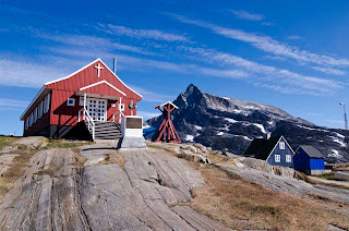
Kuummiut
On leaving the Sermilik Fjord, I will paddle up to the small settlement of Kuummiut, a place of much friendship and laughter, and then continue on up a narrow, dramatic valley staying in a small hut called simply, the Blue Hut. The next day I will paddle up to an area of tidal glaciers, possibly camping at Knud Rassmussen Glacier.

Last time we camped at nearby Karale Glacier and from a small rise I was able to count 29 glaciers in a 360 degree view!! This is the land of ice and glaciers.


Moonrise over Apeserajik
 Leaving Knud Rassmussen Glacier I will begin making my way back to Tassilaq, 85kms distant.
I plan to be on the water for 10 days, covering approximately 300 kms but naturally allowance must be made for bad weather holding me up. I will be receiving forecasts by Satphone and I will also have a neat little unit called a DeLorme InReach Messenger with me. This unit pairs with an iPhone and enables the sending of messages or emails from the iPhone to recipients via satellite.

Weather forecasts will be vital for safe travel here and they will dictate my movements totally. Travelling alone, I am aware that all decisions and judgements need to be conservative and safety based so during unsettled or bad weather I will stop and wait.


Mountains of Kong Oscar Havn

There is a minor but still present risk of running into a polar bear or "ice' bear. These animals get carried south down the Greenland coast on ice floes and occasionally end up in the Ammassalik region in summer. They have the potential to be dangerous to humans so I will be carrying a 12 gauge shotgun with me loaded with solid slugs. I will also have a trip wire system to place around my tent at night to alert me to the presence of a bear should one come close to the tent. Even though the likelihood of seeing a bear is very remote, the trip wire system will help me sleep at night....


Sermilik Fjord evening